The Marianas Plate
The Northwestern Pacific Ocean region is made up of a succession of three tectonic plates. From the most western, moderately-sized and roughly equant Philippine Sea plate, to the small crescent-shaped Marianas Plate and lastly, to the east, the vast Pacific Plate. Of interest in this region is an interoceanic subduction zone, island arc, and back arc basin system, part of the larger Izu-Bonin-Mariana (IBM) Arc extending north to Japan. (Hussong et al. 1981) The Marianas Trench is home to the deepest seafloor in the world at Challenger deep.
|
The Marianas is a microplate with a relatively small area of 360,000km2. (geology.about.com) The plate is entirely overlain by ocean, with exception of the Mariana Islands, an east-convex line of stratovolcanoes. The United States territory of Guam is the southernmost, largest and most populated island of the arc. (iris.edu) The islands are formed of volcanic rocks and Pleistocene-age calcareous sedimentary rocks. (Mueller et al. 2012)
|
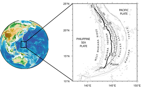
Geographic and tectonic setting of the Mariana Trough. Heavy lines: spreading centre and active rifts. Dotted line: elevation contours of the subducting slab. Triangles: arc volcanoes. (modified after Martinez and Taylor, 2003).
|
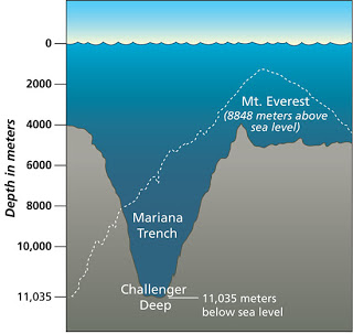
Depth of Challenger Deep relative to height of Mount Everest. (nextbigfuture.com)
|
To the west of the island arc is the Mariana trough, where there is extension and formation of a back-arc basin. This region mostly consists of turbiditic sequences of volcaniclastic sediments derived from the Mariana Arc, that overlie igneous rocks formed from the crustal spreading. (Hussong et al. 1981) Extension across the back-arc is symmetrical at a full rate of 4.7 cm/yr, and began about 3 Ma. (Sella et al. 2002, Jaxybulatov et al. 2012)
|
The West Mariana Ridge marks the western boundary between the Philippine Sea plate and the Marianas plate. Bathymetry mapping of the western flank of the West Mariana Ridge (WMR) and adjoining region of the Parece Vela Basin (PVB) show volcanoes which are relatively peaked and shallow, indicating that there has probably been uplift in the region since it became dormant around 7 Ma. The volcanoes to the north have intensely eroded flanks compared to those in the south, indicating a direction of general younging. A series of well-developed, active channel systems incise the volcanic sediment cover of ash-rich pelagic clay on the western flank of the West Mariana Ridge. (Gardner 2010)
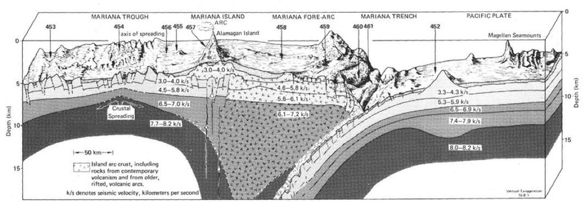
Physiographic diagram and crustal structure across the Mariana Trench, arc and trough. (Hussong et al., 1981)
To the east of the island arc is the Marianas Trench, which has formed in response to northwestward subduction of the Pacific tectonic plate beneath the Philippine Sea plate. (Mueller et al. 2012) The subduction velocity for the Pacific plate relative to Guam is 6.3cm/yr at an azimuth of 285°. (Sella et al. 2002) The configuration of the subducting plate itself changes as the trench strike goes from NNW, around the northern Mariana Islands to ENE, southwest of Guam. (Mueller et al.2012) Importantly, there are variations in the length and dipping angle of the slab beneath the arc all along the IBM system. For the northern and central Mariana segment, the subducting slab is nearly vertical, which is due in part to the incredibly dense and cold 180 Ma subducting Pacific lithosphere. (Jaxybulatov et al. 2012, news.nationalgeographic. com) However it is also probable that this geometry the result of a complex tectonic history.
|
The Marianas subduction zone's curved arrangement contrasts the northern, straighter portion of the IBM arc. It has been suggested that this shape was created by pinning of the arc as two aseismic ridges, the Caroline Island Ridge and the Marcus-Necker ridge, collided at the trench. This idea was explored by Vogt et al. in their 1976 GSA publication:
"Ridges on downgoing plates would pin the subduction zones and cause cusps to develop. The downthrust lithosphere between these cusps then attempts to adjust its dip and curvature to minimize strain." As the drive for subduction persisted, space for the downgoing slab was dwindling, and eventually the slab was torn. P-wave tomographic imaging was recently employed to confirm this hypothesis, and sure enough a distinct change in morphology of the slab south of 14.5°N was been discovered; it coincides with the location of a seismic velocity anomaly. This is a newly identified, E-W striking slab tear at the junction between steeply dipping slab penetrating vertically into the lower mantle along the central Mariana arc, where earthquakes occur to depths around 650km, and a short WSW-trending slab in the southern Mariana arc, where only shallow depth (< 250km) earthquakes are present. (Miller et al. 2006) |
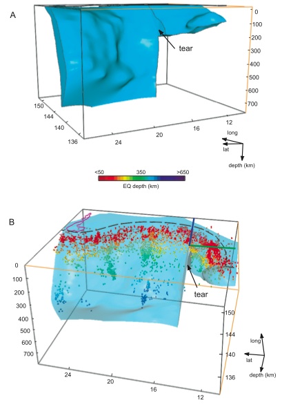
3D model of the morphology and geometry of the subducting slab beneath the Mariana arc. Blue line: projection of the EW trending tear. Green line: projection of the NS trending tear. Black dashed line: plate boundary. Purple line: position of the Ogasawara Plateau. Colored dots: distribution of seismicity within the subducting slab. (Miller et al, 2006)
|
References
Alden, A. (2014). The World's Lithospheric Plates. Retrieved from http://geology.about.com library/bl/blplate_size_table.htm
Gardner, J. V. (2010), The West Mariana Ridge, western Pacific Ocean: Geomorphology and processes from new multibeam data, GSA Bulletin 122(9-10): p. 1378–1388
Hussong D. M., S. Uyeda, R. Knapp, H. Ellis, S. Kling, and J. Natland (1981), Deep Sea Drilling Project Leg 60: Cruise Objectives, Principal Results, and Explanatory Notes. Initial Report on Deep Sea Drill Project 60: p. 3–28
IRIS (2013), Magnitude 6.8, MARIANA ISLANDS, Tuesday, May 14, 2013 at 00:32:25 UTC [PowerPoint slides]. Retrieved from http://www.iris.edu/hq/files/programs%20education_and_outreach/retm/tm_130514_mariana/130514Mariana.pdf
Jaxybulatov, K., I. Koulakov, and N. L. Dobretsov (2012), Segmentation of the Izu-Bonin and Mariana plates based on the analysis of the Benioff seismicity distribution and regional tomography results, Solid Earth Discussions 4: p. 823–850
Lovett, R. A. (April 5, 2012). How the Mariana Trench Became Earth's Deepest Point. Retrieved from http://news.nationalgeographic.com/news/2012/04/120405-james-cameron-mariana-trench%20deepseachallenger-oceans-science/
Martinez, F., and Taylor, B. (2003). Controls on back-arc crustal accretion: insights from the Lau, Manus and Mariana basins, SPECIAL PUBLICATION-GEOLOGICAL SOCIETY OF LONDON 219, p. 19-54
Miller, M. S., A. Gorbatov, and B. L. N. Kennett (2006), Three-dimensional visualization of a near vertical slab tear beneath the southern Mariana arc, Geochemistry Geophysics Geosystems 7(6): Q06012
Mueller, C. S., K. M. Haller, M. D. Luco, Nicholas, Petersen, and A.D. Frankel (2012), Seismic hazard assessment for Guam and the Northern Mariana Islands, U.S. Geological Survey Open-File Report 1015: 52 p.
Sella, G. F., T. H. Dixon, and A. Mao (2002), REVEL—A model for Recent plate velocities from space geodesy, Journal of Geophysical Research 107(B4): p. 1–30
Vogt, P. R., Lowrie, A., Bracey, D.R., and Hey, R.N. (1976), Subduction of Aseismic Oceanic Ridges: Effects on Shape, Seismicity, and Other Characteristics of Consuming Plate Boundaries, Geological Society of America Special Paper, pp. 172
Page created by Emily Fitzhenry.
