Natural Hazards in Southeast Asia
Earthquakes
|
Earthquakes occur due to a slip on a fault causing the ground to shake. They are extremely common in areas of convergence, specifically subduction zones. The subduction of the Pacific plate beneath the Philippine Sea plate has formed the Mariana’s trench which has been subject to several earthquakes in the past. However, it is uncommon to see extremely large earthquakes in this area due to the weak interplate coupling (Mueller et al. 2012). Since 1964, the largest earthquake recorded had a moment magnitude (Mw) of 6.5 in 2002 occurring in the megathrust zone of the fault at a depth from 0-40km.
|
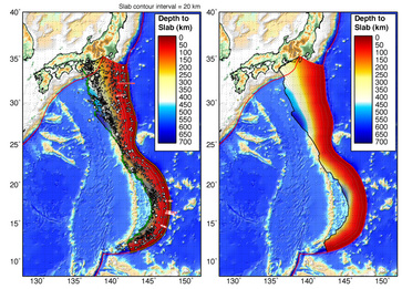
Figure 1. Demonstration of the seismic activity around the Mariana's Trench and local small earthquakes in the area (Source: USGS, 2012).
|
BEWARE!! People living around the Mariana's Trench must beware of the possibility of Godzilla returning back to Japan after the Fukushima nuclear disaster. Godzilla has taken cover in the deepest part of the trench, Challenger Deep, where he will remain to avoid the disasters of mankind (Covington, 2013).
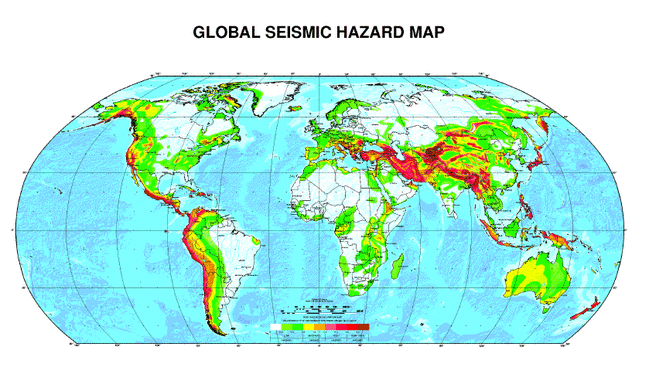
Figure 2. Global seismic hazard map demonstrating areas prone to intense seismic activity with areas in red indicating high activity and areas in white low activity. (Source: Global Seismic Hazard Assessment Program, http://www.seismo.ethz.ch/static/GSHAP/global/)
In a similar location to the Mariana’s Trench is the subduction of the South American plate beneath the micro-South Sandwich plate where several small earthquakes have occurred in past with only 3 earthquakes greater than magnitude 6 (Brett, 1977).
Towns and cities near areas of convergence should exercise extreme caution due to the highly likelihood of an earthquake occurring. Figure 2 demonstrates the areas around the world with high seismic activity suggesting that necessary precautions should especially be taken for those areas colored in red. Earthquakes continue to occur in the Southeastern part of Asia. A magnitude 5.0 earthquake occurred on January 28, 2014 off the east coast of Honshu, Japan. The active motion of converging, diverging boundaries and transform faults permit earthquakes to occur around the world where the high hazard areas are illustrated in Figure 2.
Towns and cities near areas of convergence should exercise extreme caution due to the highly likelihood of an earthquake occurring. Figure 2 demonstrates the areas around the world with high seismic activity suggesting that necessary precautions should especially be taken for those areas colored in red. Earthquakes continue to occur in the Southeastern part of Asia. A magnitude 5.0 earthquake occurred on January 28, 2014 off the east coast of Honshu, Japan. The active motion of converging, diverging boundaries and transform faults permit earthquakes to occur around the world where the high hazard areas are illustrated in Figure 2.
Tsunamis
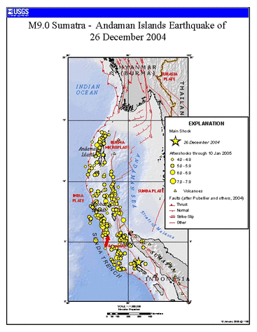
Figure 3. Map of Dec. 26, 2004 earthquake and location of aftershocks. The 2004 earthquake is indicated by the big yellow star on the southern part of the trench (Source: USGS, 2005)
|
Tsunamis are extremely large ocean waves created by the movement of the sea floor usually due to an earthquake. Figure 3 illustrates the location of the M9.1 earthquake of December 26, 2004 off the coast of Sumatra. The earthquake occurred due to the subduction of the India plate beneath the Burma micro-plate (USGS, 2013). A lateral displacement of 20m and a vertical displacement of 7m caused a tsunami wave to travel through the ocean at a speed of 500-800km/hr (Saatcioglu et al. 2005) towards the Sumatra coastline. This wave travelled around the world where the specific locations are noted in Figure 4.
|
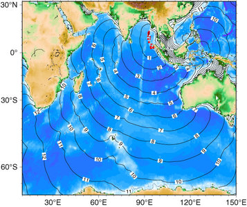 Figure 4. Tsunami travel time.
The wave approached the coastlines at peak heights of 20-30m inundating the coastline and up to 4km inland (Saatcioglu et al. 2005). Over 283,000 deaths (Lay et al. 2005) were associated with the tsunami wave generated from the thrust-fault earthquake. As can be seen in Figure 4, the wave did not only hit the coast of Sumatra, but traveled across the ocean coming in contact with the northern coast of Australia, eastern coast of Africa and even reached Antarctica.
A similar event occurred in Chile in 1960 where an earthquake of magnitude 9.5 generated a tsunami with wave heights up to 25m. These waves were carried 3km inland killing 61 people. Even though this event was larger than the Sumatra earthquake, the death toll was much less (1,655 people total) and the tsunami wave that was generated was smaller than that of the Sumatra earthquake (USGS, 2012). Several other events similar to the Sumatra earthquake have occurred in the past being the M9.0 earthquake in Kamchatka in 1952, M9.1 Andreanof Islands of 1957, and the M9.2 Alaska earthquake of 1964 all resulting from the mega-thrust events due to the subduction of one plate beneath another (USGS, 2005).
A similar event occurred in Chile in 1960 where an earthquake of magnitude 9.5 generated a tsunami with wave heights up to 25m. These waves were carried 3km inland killing 61 people. Even though this event was larger than the Sumatra earthquake, the death toll was much less (1,655 people total) and the tsunami wave that was generated was smaller than that of the Sumatra earthquake (USGS, 2012). Several other events similar to the Sumatra earthquake have occurred in the past being the M9.0 earthquake in Kamchatka in 1952, M9.1 Andreanof Islands of 1957, and the M9.2 Alaska earthquake of 1964 all resulting from the mega-thrust events due to the subduction of one plate beneath another (USGS, 2005).
Volcanoes
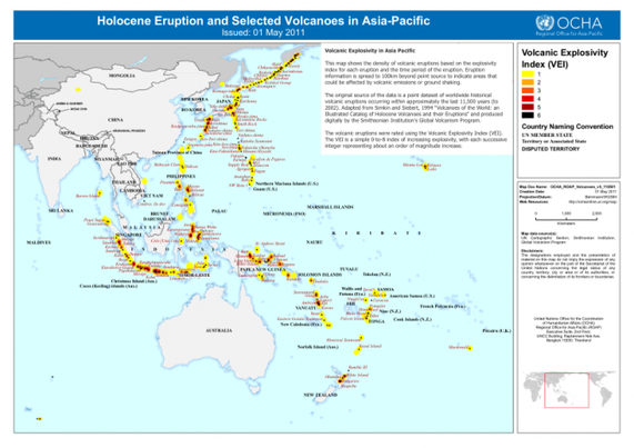
Figure 5. Demonstration of the volcanic hazards around Asia for the past 11,500 years (Source: http://reliefweb.int/sites/reliefweb.int/files/resources/map_619.pdf)
Volcanoes form in several tectonic settings such as
divergent, convergent boundaries or hot spot plumes which can be seen in Figure 5. Around the multiple convergent boundaries in
Asia, several volcanoes have formed. There is a chain of
composite volcanoes on the island of Luzon due to the subduction of the Manila
Trench which can be noted in Figure 6. A significant volcano located on the island of Luzon, Philippines formed
from the subduction of the Philippine Sea plate under the continental Eurasian
plate; Mount Pinatubo. After being dormant for more than 500
years, the 1991 eruption caused global damage from the gas and ash emissions (Newhall et al. 2005).
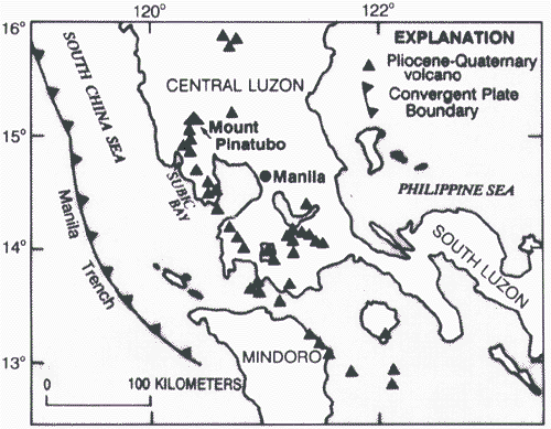
Figure 6. Location of the volcanic arc on the island of Luzon, Philippines (Source: USGS, 1999).
|
On June 15, 1991 an explosive eruption from Mount Pinatubo created lahars, pyroclastic flows and an extremely large ash cloud. A tropical storm (Yunya) was passing through the area at the same time of the eruption resulting in more extensive damage than expected. The precursor to this event was a magnitude 7.8 earthquake on the island of Luzon followed by several smaller earthquakes initiating several explosions from the volcano. These smaller earthquakes permitted seismologists to alert the towns that an eruption was imminent. Luckily 58,000 people were able to be evacuated from this devastating event leaving 200-800 people dead (geography.about.com). A global temperature decrease of 0.5 C was due to the distribution of the ash cloud around the globe.
|
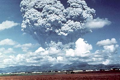
Figure 7. The devastating eruption from Mount Pinatubo emitting an extremely large ash cloud into the atmosphere in 1991. (Source: USGS, 2005)
|
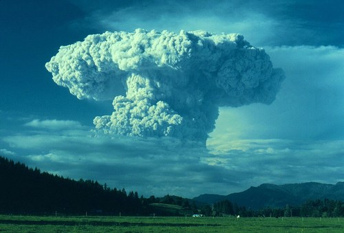
Figure 8. Ash cloud created from the Mount St. Helen's eruption of 1980 (Source: http://mw2.google.com/mw-panoramio/photos/medium/17652863.jpg)
|
Similar to the Mount Pinatubo eruption is that of Mount St. Helen’s located in the Pacific Ring of Fire where the Juan de Fuca plate is subducting beneath the North America plate. The last major eruption was in 1980 and last for 9 hours killing 27 people. A continued risk around Mount St. Helen's persists due to the increasing population in the area (USGS, 2013). The extent of the eruption can be seen in Figure 8. Figures 7 and 8 demonstrate the ash emitted from each eruption creating devastating effects felt globally.
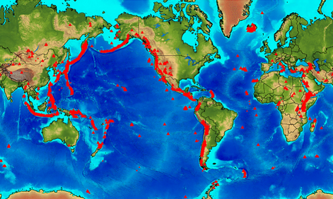 Figure 9. Pacific Rim of Fire
(Source: http://engwell.wikispaces.com)
Figure 9. Pacific Rim of Fire
(Source: http://engwell.wikispaces.com)
The areas that should be concerned the most about volcanic eruptions would be those located around the Pacific Ring of Fire. Figure 9 demonstrates the volcanoes around the Pacific plate which are all considered to be part of the Ring of Fire.
Hazards from each of these examples are associated with the movement of tectonic plates. The following slide show demonstrates pictures of the devastation experienced from volcanic eruptions, earthquakes and tsunamis. Certain areas are at a greater risk than others suggesting locals to be familiar with their region to avoid unnecessary damages associated with these natural events.
Slideshow of photos from the devastation due to the natural hazards
| reference__list.doc |
References
Brett, C. P. (1977). Seismicity of the South Sandwich Islands Region. Geophysical Journal of the Royal Astronomical Society, 51(2), 453-464.
Covington III, N. J. (September 4, 2013). Fearing the Worst Godzilla Flees Japan! National Report, January 27, 2014.
Hasegawa, A., Nakajima, J., Yanada, T., Uchida, N., Okada, T., Zhao, D., Umino, N. (2013). Complex Slab Structure and Arc Magmatism Beneath the Japanese Islands. Journal of Asian Earth Sciences, 78(0), 277-290.
Kaneshima, S., & Helffrich, G. (1998). Detection of Lower Mantle Scatterers Northeast of the Marianna Subduction Zone Using Short-Period Array Data. Journal of Geophysical Research: Solid Earth, 103(B3), 4825-4838.
Liu, Y., Santos, A., Wang, S. M., Shi, Y., Liu, H., & Yuen, D. A. (2007). Tsunami Hazards Along Chinese Coast From Potential Earthquakes in South China Sea. Physics of the Earth and Planetary Interiors, 163(1–4), 233-244.
Newhall, C., Hendley II, J. W., & Stauffer, P. H. (2005). The Cataclysmic 1991 Eruption of Mount Pinatubo, Philippines. Vancouver, WA: USGS.
Ohkura, T. (2000). Structure of the Upper Part of the Philippine Sea Plate Estimated by Later Phases of Upper Mantle Earthquakes in and Around Shikoku, Japan. Tectonophysics, 321(1), 17-36.
Saatcioglu, M., Ghobarah, A., & Nistor, I. (2005). The December 26, 2004 Sumatra Earthquake and Tsunami.The Canadien Association for Earthquake Engineering.
Tibaldi, A., Corazzato, C., Kozhurin, A., Lagmay, A. F. M., Pasquarè, F. A., Ponomareva, V. V Vezzoli, L. (2008). Influence of Substrate Tectonic Heritage on the Evolution of Composite Volcanoes: Predicting Sites of Flank Eruption, Lateral Collapse, and Erosion. Global and Planetary Change, 61(3–4), 151-174.
Page created by Michelle Vokaty. Last edited Jan 29, 2014.
